
Fichier:Northern Ireland counties + districts.png

Taille de cet aperçu : 746 × 599 pixels. Autres résolutions : 299 × 240 pixels | 598 × 480 pixels | 956 × 768 pixels | 1 275 × 1 024 pixels | 1 672 × 1 343 pixels.
Fichier d’origine (1 672 × 1 343 pixels, taille du fichier : 441 kio, type MIME : image/png)
Ce fichier provient de Wikimedia Commons.
Les informations le concernant sont affichées dans cette page de description qui est copiée ci-dessous.
Commons est un serveur de fichiers sous licence libre. Vous pouvez aider (procédure). |

Description
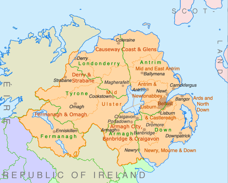
| Description | Counties and disticts of Northern Ireland |
| Date | |
| Source | File:Counties of Ireland.svg & File:United Kingdom Northern Ireland adm location map.svg |
| Auteur | Ulamm (d) |
Conditions d’utilisation
Moi, en tant que détenteur des droits d’auteur sur cette œuvre, je la publie sous les licences suivantes :

|
Vous avez la permission de copier, distribuer et modifier ce document selon les termes de la GNU Free Documentation License version 1.2 ou toute version ultérieure publiée par la Free Software Foundation, sans sections inaltérables, sans texte de première page de couverture et sans texte de dernière page de couverture. Un exemplaire de la licence est inclus dans la section intitulée GNU Free Documentation License. |
This file is licensed under the Creative Commons Attribution-Share Alike 4.0 International, 3.0 Unported, 2.5 Generic, 2.0 Generic and 1.0 Generic license.
- Vous êtes libre :
- de partager – de copier, distribuer et transmettre cette œuvre
- d’adapter – de modifier cette œuvre
- Sous les conditions suivantes :
- paternité – Vous devez donner les informations appropriées concernant l'auteur, fournir un lien vers la licence et indiquer si des modifications ont été faites. Vous pouvez faire cela par tout moyen raisonnable, mais en aucune façon suggérant que l’auteur vous soutient ou approuve l’utilisation que vous en faites.
- partage à l’identique – Si vous modifiez, transformez, ou vous basez sur cette œuvre, vous devez distribuer votre contribution sous la même licence ou une licence compatible avec celle de l’original.
Vous pouvez choisir l’une de ces licences.
Historique du fichier
Cliquer sur une date et heure pour voir le fichier tel qu'il était à ce moment-là.
| Date et heure | Vignette | Dimensions | Utilisateur | Commentaire | |
|---|---|---|---|---|---|
| actuel | 9 juillet 2022 à 22:28 | | 1 672 × 1 343 (441 kio) | Ulamm | some more names |
| 8 juillet 2022 à 22:31 |  | 1 672 × 1 343 (426 kio) | Ulamm | + some places | |
| 6 juillet 2022 à 12:38 |  | 1 672 × 1 343 (383 kio) | Ulamm | + Mid Ulster | |
| 6 juillet 2022 à 12:03 |  | 1 672 × 1 343 (381 kio) | Ulamm | {{Information |Description=Counties and disticts of Northern Ireland |Source=File:Counties of Ireland.svg & File:United Kingdom Northern Ireland adm location map.svg |Date=2022-07-06 |Author=Ulamm (<span class="signature-talk">{{int:Talkpagelinktext}}</span>) |Permission= |other_versions= }} Category:Maps of Northern Ireland Category:Maps by Ulamm == {{int:license-header}} == {{self|GFDL|cc-by-sa-all|migration=redundant}} |
Utilisation du fichier
Aucune page n’utilise ce fichier.
Usage global du fichier
Les autres wikis suivants utilisent ce fichier :
- Utilisation sur de.wikipedia.org
- Utilisation sur ie.wikipedia.org
- Utilisation sur mt.wikipedia.org