
Fichier:2022-07-15 - Wildfires in France.jpg
Fichier d’origine (2 409 × 2 085 pixels, taille du fichier : 568 kio, type MIME : image/jpeg)
Ce fichier provient de Wikimedia Commons.
Les informations le concernant sont affichées dans cette page de description qui est copiée ci-dessous.
Commons est un serveur de fichiers sous licence libre. Vous pouvez aider (procédure). |

Description
| Description |
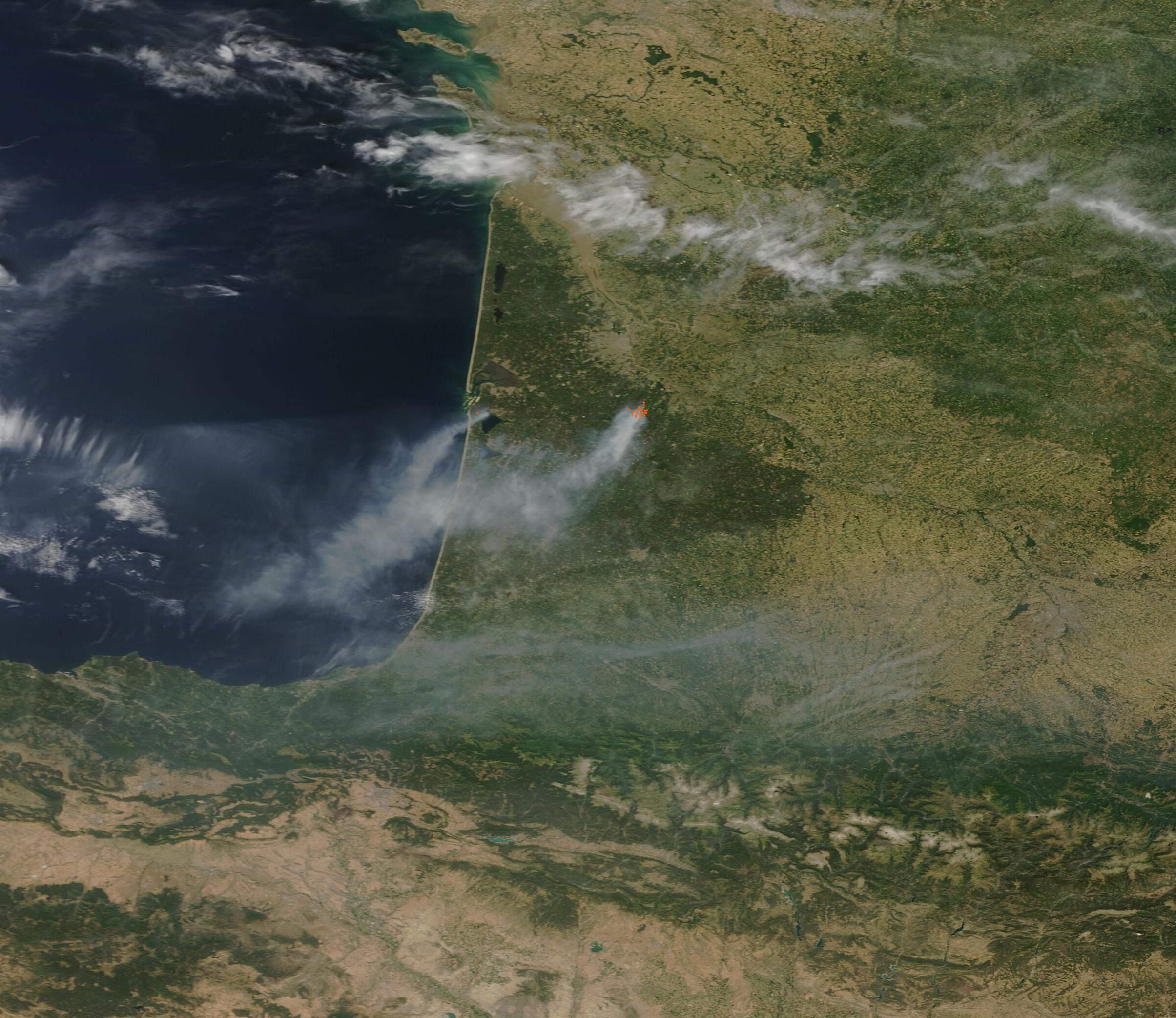
English: An extremely dry spring followed by two blistering heat waves within 30 days, helped set the scene for wildfire outbreaks across Western Europe in mid-July 2022. On July 15, the Moderate Resolution Imaging Spectroradiometer (MODIS) on board NASA’s Terra satellite acquired a true-color image fires burning in the Gironde department of France.
Copious smoke rises from two large fires, each marked by red “hot spots”— areas where the thermal bands on the MODIS instrument detected high temperatures. One of the major fire burns in the pine forests near La Teste-de-Buch, a town lying on the south shore of Arcachon Bay near the Atlantic Ocean. The fire, which started on July 12, had burned more than 6,500 hectares (16,062 acres) by July 17 and caused evacuation of at least 10,000 residents and tourists. It is said to have reached the Atlantic beaches, causing the closure of tourist favorites such as La Lagune and Petit Nice beach. The second major wildfire sits inland, south of the city of Bordeaux and near the town of Landiras. As of July 17, more than 3,100 hectares (7,660 acres) have been scorched and more than 2,000 people evacuated. Temperatures reached record-breaking levels in France this past week. On July 14, the town of St-Jean-de-Minervois recorded a high of 40˚C (104˚F), setting a record for the earliest date in the year that mainland France has ever reached that temperature. Temperatures are forecast to reach 40.6˚C (105˚F) on Monday, July 19 in Bordeaux. The continuing heat, along with windy weather and low humidity levels, brings high risk of fire spread and new fire ignition, not just to south-western France but also to much of Western Europe over the next several days. |
| Date | |
| Source | https://modis.gsfc.nasa.gov/gallery/individual.php?db_date=2022-07-18 |
| Auteur | MODIS Land Rapid Response Team, NASA GSFC |
Conditions d’utilisation
| Ce fichier provient de la NASA. Sauf exception, les documents créés par la NASA ne sont pas soumis à copyright. Pour plus d'informations, voir la politique de copyright de la NASA. | ||
 |
Attention :
|
Historique du fichier
Cliquer sur une date et heure pour voir le fichier tel qu'il était à ce moment-là.
| Date et heure | Vignette | Dimensions | Utilisateur | Commentaire | |
|---|---|---|---|---|---|
| actuel | 18 juillet 2022 à 23:09 | | 2 409 × 2 085 (568 kio) | Don-vip | full-res |
| 18 juillet 2022 à 23:07 |  | 600 × 520 (277 kio) | Don-vip | Uploaded a work by MODIS Land Rapid Response Team, NASA GSFC from https://modis.gsfc.nasa.gov/gallery/individual.php?db_date=2022-07-18 with UploadWizard |
Utilisation du fichier
La page suivante utilise ce fichier :
Usage global du fichier
Les autres wikis suivants utilisent ce fichier :
- Utilisation sur en.wikipedia.org
- Utilisation sur fr.wikipedia.org
- Utilisation sur he.wikipedia.org
- Utilisation sur pt.wikipedia.org
- Utilisation sur www.wikidata.org